Appearance
Mobile photos
Mobile photos enables you take photographs on your iPhone or Android device and upload them to MVOW. If you take photos that can only be uploaded later, you can also upload individual photos from your computer once you get back to the office.
This documentation assumes that you're accessing the MVOW Mobile photo page on a phone. The screen shots are based on this, and if you view the page on a laptop or desktop computer, the pages will look quite different.
How to access mobile photos
There are two ways to get into this page.
- Clicking the Mobile photos menu item from the main menu, OR
- Clicking the camera
 icon at the top of the Property update page or Analysis update page.
If you access mobile photos from the menu item, the page will come into view with the GPS tab selected.
If you access mobile photos from the update pages, the PID tab will be selected.
GPS tab
Here's what theGPS tab looks like on an Android phone.
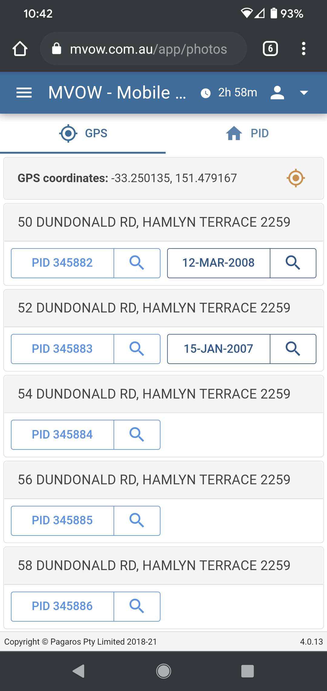
If you look at this on your phone, you'll have to give the browser access to your location services. Once the system has your GPS coordinates, it'll go to the server, find the 6 properties closest to your location, and display them in proximity order. It will display a button for the property, and if an analysis exists, it'll display a button for the analysis as well.
- Each button is split into two parts. If you tap the main part of the button, you'll be able to take a photo and attach it to the property or analysis, depending on which button you tapped.
- If you tap the Search
 button on the right part of the button, it'll take you to the Property update or Analysis update pages. You'll then have to go back to get to the GPS page you just left.
 - Alternatively, you'll see that there is a button with a camera icon on the Update page. That will take you to the PID tab of this page.
- We say above that the server will find the 6 properties closest to your location. This is what the server does by default, but you can set the number of properties it will give you in the Contractor | Options | Attachments | GPS nearest property count text field.
PID tab
As mentioned, Update pages include a camera icon:
Clicking the camera icon will take you to the PID tab on the Mobile photos page.
In this example, I've picked a property with two analyses.
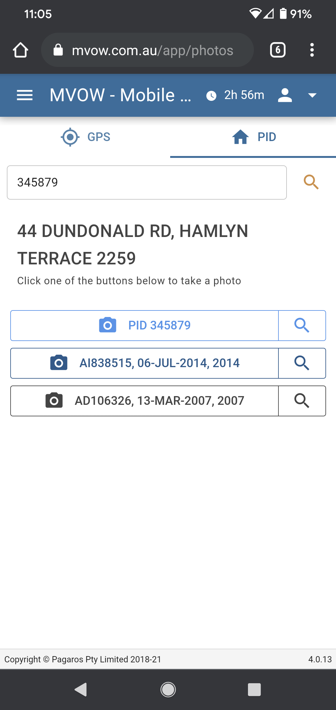
What you'll see here is a button for taking a photo to attach to the property, and another set of buttons for taking photos to attach to analyses. If you come here from a property, the most recent analysis will be blue. If you come here from an analysis, the analysis you came from will be blue. As for the GPS tab, the buttons are split to sections for taking a photo and for navigating to the property or analysis.
There is an input box at the top of the page. You can enter a PID there, and the system will find the property and any analyses that exist, sorted and presented so that the most recent analysis is at the top.
What happens to analyses
There are some changes that have taken place on the server to make this process a little smoother.
First, if you take a photo from this page and attach it to an analysis, the photo will be attached to the analysis and the Has photo box on the analysis will be ticked.
Second, if you have the Contractor | Options | Images / attachments | If no inspection date for analysis, set it when photo uploaded from mobile page box ticked (it's not ticked by default), then the inspection date will be set to today's date, assuming it hasn't already been set.
Caveats
Currency of data
The GPS coordinates are not provided by VNSW. I've obtained them (legally) from this page: https://data.gov.au/dataset/ds-dga-19432f89-dc3a-4ef3-b943-5326ef1dbecc/details.
The set of GPS coordinates is correct as at 11:01:45 AM on Feb 17, 2020, but the data is only updated quarterly.
Distance from your location
If you're on the GPS tab, the system will only locate properties within a 5 kilometre radius of your location. This means that if you're working in a place where the property centroid is more than 5 kilometres away, your property won't show up and you'll need to have the PID handy instead. I would imagine that this is only likely in the more remote areas of the state.
So, if you’re trying to show off MVOW's capabilities to someone when you're away from your contract area and surrounding districts, you're not going to have any properties show up on the page.
Again, you'll have to enter a PID or come to this page from a property entry or analysis.
Implications
GPS coordinates aren't available for supps and newly created properties.
Specifically, GPS coordinates aren't available for sales on properties that are new. I don't know what percentage of your analyses are on new properties, but I suspect that it's a sizeable proportion. It means that for these analyses, you won't be able to drive up to them, go to the mobile photos page and have the analysis just show up. You'll have to enter the PID on the PID tab.
There is a way through this problem, and that is to lobby VNSW to have the property centroid coordinates included in the property, supp and sale data files.